• Skip to primary navigation
  • Skip to main content
  • Skip to primary sidebar
Far Western

Far Western

Far Western Anthropological Research Group, Inc., is a leader in cultural resources management services. Since 1979, Far Western has consulted in archaeological projects for private industry, government agencies, tribal organizations, and non-profit groups, to achieve the broader goals of the environmental review and compliance process.

  • SERVICES
    • Archaeobotanical Analysis
    • Artifact Analysis and Collections Management
    • Bioarchaeology
    • Effects Mitigation
    • Environmental Planning Support
    • Evaluation and Testing
    • Geoarchaeology
    • GIS and Cartography
    • Historical Archaeology
    • Inventory
    • Monitoring
    • Paleontological Services
    • Public Outreach and Interpretation
    • Sensitivity and Constraints
    • Tribal Liaison
    • Underwater Archaeology
    • XRF Lab and Sourcing Studies
  • OFFICES
    • Contact Us
    • Main Office – Davis, CA
    • Bay Area Branch – Sausalito, CA
    • Desert Branch – Henderson, NV
    • Great Basin Branch – Carson City, NV
  • STAFF DIRECTORY
    • Full Directory
    • Far Western Principals
    • Principal Investigators
    • Geoarchaeologists
    • Historical Archaeologists
    • Senior Archaeologists
    • Staff Archaeologists
    • Laboratory and Collections Management
    • GIS and Cartography Specialists
    • Data Management
    • Bioarchaeologists
    • Graphic Design and Publishing
    • Administration
  • PUBLICATIONS
    • Our Publications
    • Selected Citations
  • ABOUT ARCHAEOLOGY
    • What is Archaeology?
    • Featured Videos
    • Public Outreach and Interpretation
    • Featured Projects
    • Visualization Gallery
  • NEWS
    • News Posts
    • Far Western Occasional Speaker Series
    • Subscribe to Far Western News
  • JOB POSTINGS
You are here: Home / News

News

Cuyama Valley Digital Booklet, Exhibits, and 3D Gallery

Molly · May 21, 2015 ·

TLRTIn the late 1960s and early 1970s, the California Division of Highways carried out three highway realignment projects in Cuyama Valley, San Luis Obispo and Santa Barbara counties. Salvage archaeological work was conducted at seven sites, but the resulting extensive collections were never formally catalogued or documented.

Some 40 years later, the California Department of Transportation awarded Far Western a Transportation Enhancement grant to analyze and document the Cuyama Valley archaeological collections. The  result is entitled Cuyama Valley – A Corridor to the Past.

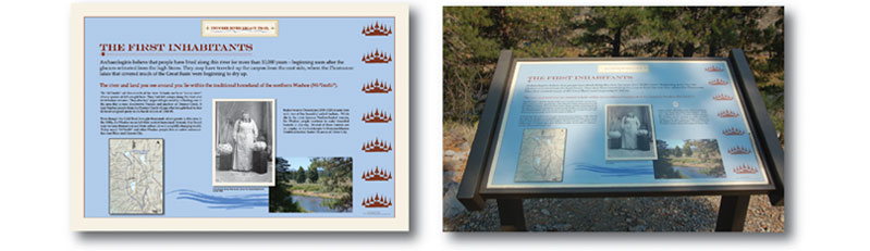
The Cuyama Valley story is also presented in a booklet for the public called The Long Road Traveled by Patricia Mikkelsen, Paula Juelke Carr, Shelly Tiley, Julia Costello, Nathan Stevens, and John R. Johnson. Read it HERE!

We created a 3D gallery as part of the digital booklet. Spin and view the 3D Visualization Gallery HERE!

This publication honors Dr. Valerie Levulett, who initiated the Cuyama Valley project.

She was instrumental in ensuring that the gathered information be made available to researchers and the public alike.

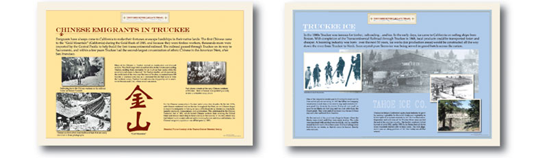
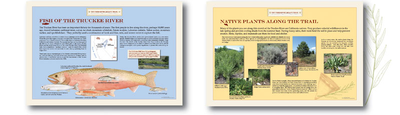
Far Western also designed and fabricated two sets of portable exhibits and a set of four bookmarks to be used by members of the Chumash Indian community.

Portable Exhibit 2

This project was a collaborative partnership among the Native American community, the District 5 Central Coast Specialist Branch of the California Department of Transportation, Far Western, the Santa Barbara Museum of Natural History, Foothill Resources, and Tiley Research, among others. We thank the many individuals who contributed their talents to this project, and particularly want to recognize the Native Americans with ties to Cuyama Valley who generously shared their time and stories with us.

We also wish to acknowledge the generous support of the California Transportation Commission, who made it possible to complete the proper processing and curation of the Cuyama archaeological collection. This study has opened up new and important vistas on the prehistory and early history of the Cuyama Valley corridor.

SHARE THIS: Share on Facebook Share on Google+ Share on LinkedIn Email this to someone

California Transportation Award Nomination

Molly · May 12, 2015 ·

The First Inhabitants Board

Far Western recently completed work on the Truckee River Legacy Trail in Nevada County, California. This long-term contract included site evaluations, data recovery, public interpretation, and a series of reports and treatment plans for the California Department of Transportation, the Tahoe National Forest, and the Town of Truckee, California. Dr. Susan Lindström, Zeier & Associates, and Penny Rucks Ethnographic Services worked with Far Western on various aspects of the project.

Chinese Emigrants in Truckee and Truckee Ice

Sharon A. Waechter and Tammara Ekness-Norton designed 15 trail-side panels, as well as a trail map and brochure.

Fish of the Truckee River and Native Plants Along the Trail

The Truckee River Legacy Trail has been chosen as one of the three finalists in the Bicycle/Pedestrian Trail category for a Transportation Award from the California Transportation Foundation (CTF). Anne Mayer, Chairperson of the CTF Awards Committee, noted that the finalists “represent the best of the projects, programs, and people who made a positive difference for California transportation in 2014.” The winner will be announced at a luncheon on May 21, 2015.

For more information on the Truckee River Legacy Trail see our featured project page HERE!

See all Finalists for the California Transportation Foundation Awards HERE!

26th-Annual-Trans-Awards

SHARE THIS: Share on Facebook Share on Google+ Share on LinkedIn Email this to someone

Crescents? What Are They Good For?

Molly · May 5, 2015 ·

Mike Lenzi gave a knock-out presentation on the function of crescents. It described the results of employing experimental archaeology to compare crescents to technological alternatives (flakes and Western Stemmed Tradition points) for a variety of tasks. The presentation also related the use-wear breakage to patterns displayed by archaeological specimens. His conclusions: the primary function of crescents was likely hafted projectiles for procuring waterfowl and small game at the margins of Pluvial lakes and near wetlands.

Lenzi Defense Flier

SHARE THIS: Share on Facebook Share on Google+ Share on LinkedIn Email this to someone

San Francisco SAA 80th Meeting Successes

Molly · April 28, 2015 ·

Far Western at SAA Meeting
Laura Brink and Stephanie Bennett at the Far Western table for the 80th Annual SAA Meeting.

SAA president Jeffrey Altschul just announced that 5,323 people are attending #SAA2015! This is our largest meeting to date!
— SAA (@SAAorg) April 18, 2015


The Society for American Archaeology (SAA) met in San Francisco for their 80th Annual Meeting – their largest meeting yet! The SAA is an international organization dedicated to the research, interpretation, and protection of the archaeological heritage for the Americas. This year, Far Western was well-represented with many successful presentations, including the opening session, and poster sessions. Learn more about the Society for American Archaeology HERE.

Use the buttons below to see abstracts from Far Western presentations and collaborations!

Angela Arpaia
Plant Remains Assemblage in Santa Clara Valley

Angela Arpaia

The Santa Clara Valley has an archaeobotanical record that spans from the central California Early, Middle, and Late periods. Sites CA-SCL-12, -478, -674, and -919 have robust plant remains assemblages from distinct periods that can be used to evaluate change in plant use and land management practices. Temporal context and habitat will be compared for each site to understand variation in plant diversity and intensification.

Laura Brink
Reconstructing Mobility in the San Francisco Bay Area: Strontium and Oxygen Isotope Analysis at Two California Late Period Sites, CA-CCO-297 and CA-SCL-919

Laura Brink, Jelmer Eerkens (UC Davis), Alex DeGeorgey (Alta Archaeological Consulting), and Jeff Rosenthal

Analysis at two California Late Period sites, CA-CCO-297 and CA-SCL-919 Stable isotope analysis can reconstruct individual mobility of prehistoric California on a scale that can distinguish movement between different parts of the San Francisco Bay Area. This study uses strontium and oxygen isotope analysis to compare individual mobility patterns of two Late Period sites, CA-CCO-297 and CA-SCL-919. Three life stages are used for comparison, including early childhood from first molars, early adolescence from third molars, and adulthood/time of death from bone. Isotopic ratios from bone resulted in consistent and site-specific signatures for both sites, while enamel ratios were much more variable, suggesting higher mobility during childhood and adolescence than during adulthood. CA-SCL-919 is composed mainly of non-local individuals born in a wide variety of locations, while many individuals interred at CA-CCO-297 were born locally. Both sites revealed mobility shifts from childhood to adolescence, possibly due to post- or pre-martial residence changes. The data also suggest sexual differences in movement patterns, which may inform on post-marital residence patterns. This work gives insight into ancient kinship organization in the San Francisco Bay Area, differentiates site-specific mobility patterns from life-history mobility signatures, and provides testable hypotheses on the structure of post-marital residence patterns during the Late Period of the San Francisco Bay Area.

Ryan Byerly
Geochemical and Physical Characterization of Lithic Raw Materials in the Olduvai Basin, Tanzania

Fitzgerald, Curran (Department of Anthropology, University of North Carolina at Greensboro), Charles Egeland (Department of Anthropology, University of North Carolina), Ryan Byerly, Cynthia Fadem (Department of Geology, Earlham College), and Audax Mabulla (Archaeology Unit, University of Dar es Salaam)

The study of raw materials has traditionally been deeply embedded in analyses of the Early Stone Age, and the impact of source rock characteristics on early human ranging behavior and technological variation is now widely acknowledged. Olduvai Gorge, Tanzania, apart from being one of the most well-known paleoanthropological sites in the world, is also home to a great diversity of potential sources for the production of stone tools. While the lithology and mineralogy of these sources have been well described, quantitative data on inter- and intra-source geochemical and physical characteristics are still rare, which makes it difficult to rigorously test models of early human home ranges and raw material selectivity. This project reports preliminary quantitative studies of variation in the geochemical (via portable x-ray fluorescence) and physical (via standard engineering tools) characteristics of primary and secondary rock sources that presumably served as important supplies of toolstone for Early Pleistocene hominins at Olduvai Gorge.

Brian Byrd
The Neolithic Houses of California – An Ethnohistoric Comparative Perspective on Household and Community Organization among Complex Hunter-Gatherers

Brian Byrd

The talk addressed the built environment of complex hunter-gatherer villages of the contact period in California. Although not agriculturalists, they constitute one of the most diverse and well-documented amalgam of complex hunter-gatherers in the world. The study explores the interrelationship between vernacular architecture, households, community organization, and their socio-economic underpinnings. In doing so, highlighted case studies will include the Chumash of coastal southern California, the Patwin of central California, and the Wintu of northern California. Finally, consideration is given to the potential for ethnohistoric vernacular architecture of California hunter-gatherers to provide insight into fundamental variables in the development of Neolithic households worldwide.

Brian Byrd
Wadi Madamagh, Western Highlands of Jordan: Lithic Evidence from the Late Upper Paleolithic and Early Epipaleolithic Occupations

Olszewski, Deborah (University of Pennsylvania), Maysoon al-Nahar (University of Jordan), Daniel Schyle (University of Cologne), and Brian Byrd

Wadi Madamagh, a small rockshelter in the Petra region of the Western Highlands of Jordan, contained high-density deposits of the Late Upper Paleolithic and the Early Epipaleolithic periods. It was first excavated in 1956 by D. Kirkbride, who placed two trenches into the site and briefly reported on the lithics, which have since been studied in detail (B. F. Byrd). A small test along one of Kirkbride’s trenches was conducted in 1983 (D. Schyle), and more intensive excavations were pursued in 2011 (D. I. Olszewski and M. al-Nahar, as well as D. Schyle). As a result of decades of exposure due to the open trenches left by Kirkbride, the remaining deposits at Wadi Madamagh are unfortunately quite limited, especially those of the Early Epipaleolithic. In this paper, we address this issue in part by combining data from the lithic assemblages recovered from all three excavation seasons. This is thus the first comprehensive examination of the stone artifacts recovered from this site. It examines their significance for understanding the behavioral strategies of Late Upper Paleolithic and Early Epipaleolithic hunter-gatherer-foragers in this part of the Levantine Middle East.

Daron Duke
Haskett Spear Points and the Plausibility of Megafaunal Hunting in the Great Basin

Daron Duke

Recent Haskett projectile point finds from western Utah’s Great Salt Lake Desert provide a compelling case for megafaunal hunting in the Great Basin, a region that stands out in North America for its lack of direct evidence. The Haskett style is likely the oldest representative of the Western Stemmed series of projectile points, and radiocarbon age estimates on black mat organics at the locality suggest a date range between ca. 12,000 and 13,000 cal BP. In this paper, an argument for megafaunal hunting is constructed for critical examination against alternatives. Images and technological attributes for the collection are presented, including one 22.6-centimeter specimen that is the longest Haskett point documented archaeologically and another that tested positive to proboscidean antiserum via protein residue analysis.

Tod Hildebrandt
Divergent Histories: Prehistoric Use of Alpine Habitats in the Toquima and Toiyabe Ranges, Central Great Basin

Tod Hildebrandt

Alpine villages are extremely rare in the Great Basin. To date, villages located at elevations above 10,000 feet are only known to occur in the White Mountains and the Toquima Range. Demographic forcing and climatic change has been used to explain the existence of these villages, but these propositions do not identify more specific selective pressures that led to the establishment of high elevation villages in some ranges but not others. Comparison of artifact distributions and environmental structure in the Toquima Range, where a village exists, and the Toiyabe Range, where one does not, supports the notion that alpine villages may have been subsidized by intensive exploitation of mid-elevation pinyon groves associated with low-cost travel corridors, which facilitated transport of pine nuts to upland village locations. This study also reveals that limber pine may have played a role in alpine village subsistence, and identifies the need for further research on the value of this resource.

William Hildebrandt and Kelly McGuire
Middle Archaic Expansion into High Elevation Habitats: A View from the Southwestern Great Basin

William Hildebrandt and Kelly McGuire

Several researchers have hypothesized that high elevation habitats were not intensively used until after 4000 cal BP when lowland settlements became more stable and logistical hunting organization emerged. This paper evaluates this hypothesis by comparing the relative frequency of Pinto versus Elko/Humboldt series projectile points across a variety of lowland and upland settings in the White Mountains/Owens Valley area.

Philip Kiajankoski, Jack Meyer, and Paul Brandy
A Land Transformed: Holocene Sea-Level Rise, Landscape Evolution, and Human Occupation in the San Francisco Bay Area

Philip Kiajankoski, Jack Meyer, and Paul Brandy

Occupation in the San Francisco Bay Area The effects of landscape evolution on the archaeological record of the San Francisco Bay Area have been profound, primarily due to rising sea levels. These changes are illustrated through a trans Holocene “tour” of the bay that incorporates the landscape context of many sites featured in subsequent papers. For the region’s first inhabitants, this area was a vast inland valley rather than the state’s largest estuary. The Holocene transgression is illustrated utilizing a new sea-level curve developed for region, which is based on an analysis of over three hundred radiocarbon dates from marsh deposits in the bay and delta. This curve is used to reconstruct the extent of the bay at various times in the past, illustrating just how much of the landscape once available for prehistoric human populations is now submerged. The terrestrial response to rising sea levels during the latter portion of the Holocene included infilling of formerly incised stream channels, alluvial deposition on surrounding floodplains, and the formation of extensive wetlands and dune fields, as illustrated by recent geoarchaeological studies from the region. These examples show how large-scale landscape changes structured the region’s archaeological record, and likely explain why the early portions of California’s past are poorly represented.

Lucas Martindale Johnson
Preliminary Interpretations of the Reduction Technology and Distribution of Obsidian Cores at Caracol, Belize: Learning to Reconsider Maya “Eccentrics” and Social Relations of Ritual Objects

Lucas Martindale Johnson

To the uninitiated, Maya “eccentrics” are vague archaeological labels applied to flaked obsidian objects placed in ritual caches during the Classic Period (AD 250-800). Although labels of humanoid, deity, animal-like, or other shaped objects are often unclear, lithics analysts have tried to define eccentrics based on technological attributes to enable comparisons between contexts, sites, and regions. Those studies that reconstruct a complex chaîne opératoire demonstrate many eccentrics had a dynamic socio-technological biography prior to their deposition in ritualized contexts. After 30 years of systematic investigations, the Caracol Archaeological Project has recovered many ritual cache deposits of Maya “eccentrics”. Caracol eccentrics are typically terminated or disabled exhausted polyhedral blade cores, but can also be broadened to include (modified) macro-core shaping flakes/blades, platform preparation, and core rejuvenation debitage – all those objects that help to create and maintain, a socio-technological blade industry. The broad household ritualization of these objects through specific crafting acts demonstrates that non-blade objects were essential to social relations between obsidian crafters and socially diverse household ritual practitioners. This paper defines these ritualized objects technologically to highlight the performative production by obsidian crafters and presents their distributions at households to understand their circulation to non-crafters for use in household ritual events.

Jack Meyer
Holocene Transformation of San Francisco Bay and Transbay Man Site Stratigraphy

Jack Meyer

San Francisco Bay was created by post-glacial sea-level rise during the span of prehistoric human occupation. The Bay is the single largest Pacific estuary in the Americas (4,160 square kilometers) and is the outlet for California’s largest freshwater drainage system that carries 40% of the state’s runoff. The earliest known evidence of widespread human use of the estuary or tidal resources in the Bay Area first appears at shell midden sites located around the Bay in the middle Holocene (6300-4600 cal BP). Recently, however, an intact human skeleton (“Transbay Man”) was found at an elevation of 12.8 meters (42 feet) below sea level in downtown San Francisco, which is the fourth, and oldest (~7600 cal BP) such skeleton recovered from a submerged context in the region. The stratigraphic sequence and paleoenvironmental context of this rare and unusual find are examined in relation to Holocene sea-level rise and landscape changes that transformed the Bay Area into an ideal place for prehistoric human settlement.

Michelle Rich
From A Forest of Kings to the Forests of Peten: The Mirador Group at El Perú-Waka'

Michelle Rich

More than 10 years of research at El Perú-Waka’, carried out under the co-direction of David Freidel and several Guatemalan collaborators, has resulted in a wealth of information about this ancient city and the role its rulers and residents played in the Classic Maya world. Enhanced through his work with Linda Schele, Freidel’s persistent focus on the interplay between ancient history and archaeology—on stelae, buildings, and people—has shaped research at Waka’, located in Guatemala’s Laguna del Tigre National Park. The Mirador Group, one of the site’s principal civic ceremonial settings, was an initial focus for the El Perú-Waka’ Regional Archaeological Project. While the Mirador Group’s stelae are either blank or largely eroded, archaeological investigation of the monumental architecture has shed light on topics explored in A Forest of Kings, including the role of Teotihuacan, Tikal, and Calakmul in Classic period interactions. This paper will explore Waka’s involvement in these relationships, particularly as evidenced by the Mirador Group’s royal interments and the narrative figurine scene depicting an elaborate courtly ritual.

Nathan Stevens and Jeffrey Rosenthal
Geology, Historical Contingency, and Ecological Inheritance in California's Southern Sierra Nevada

Nathan Stevens and Jeffrey Rosenthal

The Late prehistoric archaeological record of the Southern Sierra Nevada can be distilled down to two very visible elements: bedrock mortars and obsidian. Both were imported from outside the area, with obsidian coming from the east and the idea of the bedrock mortar coming from the west. We argue that the presence of transported obsidian, much of it deposited prior to 1000 cal BP, and the later establishment of bedrock mortars encouraged more persistent use of this landscape. We see this as an example of the downstream effects of niche construction.

Adrian Whitaker and Brian Byrd
An Ideal Free Settlement Perspective on Residential Positioning in the San Francisco Bay Area

Adrian Whitaker and Brian Byrd

We present an Ideal Free Distribution Model to explore the successful establishment and spread of hunter-gatherer residential settlements around the perimeter of San Francisco Bay, California. Our objective is to illuminate underlying ecological and social factors that best explain the spatial distribution of occupation in the region. Our model determines relative habitat suitability based on a series of environmental factors including drainage catchment size, rainfall, terrestrial productivity, and littoral productivity. In doing so, we also account for diachronic shifts in shoreline location and its impact on resource distribution. Then we test this model using a robust database of more than 500 prehistoric residential sites around the Bay (of which more than a third have produced chronological data), and ethnohistoric insights into settlement location by linguistic group. The talk concludes with consideration of the effect of social as well as ecological factors in structuring temporal trends in settlement configuration and subsistence strategies that formed the basis of this rich archaeological record.

Eric Wohlgemuth
Environmental Constraints and Plant Food Intensification in the Sacramento Valley

Eric Wohlgemuth

The Sacramento Valley bottom is a rich environment for faunal resources, notably fish, but lacks staple nut crops found elsewhere in interior central California. The absence of key nut resources appears to be the key factor in intensified production of geophytes and the early intensification of small seeds, especially Chenopodium spp. These features are absent in other regions in the rich archaeobotanical record of central California.

SHARE THIS: Share on Facebook Share on Google+ Share on LinkedIn Email this to someone

Is Mojave Desert Clovis Contemporaneous with Clovis Elsewhere?

Molly · April 22, 2015 ·

Clovis Biface

In their recent article in PaleoAmerica, one of Far Western’s Principal Investigators, Ryan Byerly, and one of our Senior Archaeologists, Joanna Roberson, examine a Clovis biface and explore dating terminal Pleistocene geological deposits in Twentynine Palms, California. The type of fluted biface, made of local jasper, implies that it may have been deposited before the Younger Dryas period, and it may coincide with Clovis points dated in other locations (ca. 13,200–12,700 calibrated years before present).

“More than 30 years of cultural resources management in the Marine Corps Air Ground Combat Center (MCAGCC), Twentynine Palms, California, has produced a growing body of mostly unpublished data (cf. Sutton et al. 2007) concerning the late Pleistocene–middle Holocene archaeology of the Mojave Desert. This article highlights recent work demonstrating the presence of hunter-gatherers in the MCAGCC before the Younger Dryas, and the potential preservation of significantly ancient buried deposits in some areas.”

—Byerly and Roberson 2015

Read their article HERE.

“Late Pleistocene to Middle Holocene Archaeology in the Mojave Desert: Recent Discoveries in Twentynine Palms, California,” PaleoAmerica 1(2):197-201

The authors thank the Natural Resources and Environmental Affairs staff aboard MCAGCC, particularly Marie Cottrell, Leslie Glover, John Hale, and Nick Chamberlain, for their dedication to the management of cultural resources and providing data gleaned from those efforts for this piece. We would also like to acknowledge Mike Rondeau for taking time to analyze and identify the fluted projectile point, which was found by Devin Garvey, a Far Western archaeological technician. Geomorphological work was conducted by D. Craig Young, Andras Nagy produced the map, and Kathleen Montgomery created the other figure. Amy Gilreath manages Far Western’s work aboard MCAGCC, and Bill Hildebrandt serves as Principal Investigator for these projects. Mark Allen and three anonymous reviewers helped improve an earlier draft of the article.

SHARE THIS: Share on Facebook Share on Google+ Share on LinkedIn Email this to someone
  • « Go to Previous Page
  • Page 1
  • Interim pages omitted …
  • Page 9
  • Page 10
  • Page 11
  • Page 12
  • Page 13
  • Go to Next Page »

Primary Sidebar

CONTACT US TODAY

Main Office - Davis, CA
(530) 756-3941
Bay Area Branch - Sausalito, CA
(415) 413-1450
Desert Branch - Henderson, NV
(702) 982-3691
Great Basin Branch - Carson City, NV
(775) 847-0223

FEATURED

Visualizing Indigenous Persistence during Spanish Colonization of the San Francisco Bay Area

FAR WESTERN NEWS

McGuire Publishes in Terrain

February 15, 2024

Vickie Clay awarded the NAA Silver Trowel Lifetime Achievement

May 17, 2023

Archaeology Reveals Past Lives of Bay Area Native Tribe: Phil Gross and Far Western Produce National PBS Documentary

November 8, 2022

SUBSCRIBE TO FAR WESTERN NEWS

QUICKLINKS

Statement of Qualifications
GSA Contracting
Current On-Call List
Contact Us
Awards

SPECIAL SERVICES AND EVENTS

XRF Laboratory
Archaeobotanical Analysis
Underwater Archaeology
Public Outreach and Interpretation
Tribal Liaison
Occasional Speaker Series

CONTACT US

Main Office – Davis, CA (530) 756-3941
Bay Area Branch – Sausalito, CA (415) 413-1450
Desert Branch – Henderson, NV (702) 982-3691
Great Basin Branch – Carson City, NV (775) 847-0223

Far Western

Copyright © 2025 Far Western · Crafted by Tangerine Design · Log in

  • Statement of Qualifications
  • GSA Contracting
  • Current On-Call List
  • Contact Us
  • Awards